
The Royal River Land Trust has a page about this part of the river, found here. I found the in formation on this page helpful, especially the map. My experience on this stretch of the river did not match the description on the page, but as is the case with any river, conditions and water levels change the experience of the river.
Body of Water: Royal River From Old Town House Park towards Wescustogo Park
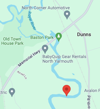
This is the map of the route, from the Royal River Land Trust. We paddled upstream and could not quite get to Wescustogo Park due to downed trees, but we got close. We then explored Chandler stream on our way back - and could not go further than the bridge at North Road (indicated as rapids on the map)

We then paddled beyond the launch, under the bridge and paddled for a short while before turning back. This Red Point shows where we turned around. (Image from Google Maps)
Directions: I looked on Google Maps and dropped a pin at the launch site I wanted to use. The pin was located here: 43°51'20.0"N 70°13'11.1"W This link should help you get there.
From Portland, head north on 295. Take Exit 17 Yarmouth/Freeport. Turn Left off the exit ramp onto Rt 1 for about 0.5 miles. Turn Right after Coastal Hardware to get to East Main St. Turn right on East Main St. then left onto North Road.
Stay on North Road for 4.2 miles, turn Left onto Rt. 9 Go just 0.2 miles and the parking area will be on the right, just after crossing a bridge. BE CAREFUL ON THE TURN INTO THE PARKING LOT. There is a bit of a drop on the opposite side of the 'driveway'

Bathroom: There are no facilities at the launch.
Parking: The parking area is small, room for up to probably 4 vehicles. Please park close together to leave as much space as possible for other people who may be coming here to paddle or enjoy the waling trail. (This is also a trailhead for the Royal River Land Trust Trails.)
I forgot to take a photo of the parking area... sorry!!
Launch: The launch is interesting - and depending on the water levels could be more or less challenging. The walk to the launch is very short from the parking area. and the slope into the water is pretty gradual. I get into my kayak by walking into the water and sitting into my kayak - and the launch was ok, but there is a bit of a drop off if you need to walk out a bit. The ground near the launch was pretty solid ( I was worried it was going to be mud or clay and I would sink, but it was good!)

Wildlife: We were struck at the lack of wildlife, to be honest. We did hear a lot of birds, but we did not see much else or signs of much else. It looked like a great habitat for otters or beavers - and we did not see any tracks of either. There were some trees that had been chewed by beavers, but it was not recent chewing. We did eventually see 2 turtles and at one point I saw 2 deer running through the woods on one of the ridges we were below. There is potential for wildlife here, and I would have thought we would have seen more! (Not even a heron!)
Notes: The day I did this part of the Royal River, it was windy. Too windy to paddle on open lakes etc, so this was perfect! The river meanders through beautiful forested areas. You feel like you are in a valley for most of this trip.. the banks of the river on both sides rise up and you feel protected. This is a great option for windy days!
I will say that this is a place where I would advise having a paddling partner. I often paddle solo and am comfortable doing so, but there are some paddles that I think having someone with you is a good idea. While this stretch of the Royal River is not a hard paddle or super dangerous, there are a lot of logs and a few rocks that unexpectedly may bump the bottom of your kayak. Should you tip - it would be good to have another person with you. And as always - I recommend wearing your life jacket, not just having it with you. This is a good place to practice your navigation skills, to paddle around obstacles!
This photo shows one area where we paddled over some logs.

My paddling partner for the day was my friend Deb! She had seen a post by the Royal River Land Trust earlier this spring that mentioned this part of the river. (I think they hosted a group paddle.) Neither one of us had explored here before and we decided to check it out. I am glad we did!
This is Deb! Photo credit for pics of me go to her! (Thank you for the pics of me that you took!)

With any river there will be a current. The strength of that current depends on many factors, water levels, path of the river and obstacles. The current in this river was stronger than I expected, based on what I had read. It was totally doable for me, within my comfort level, but there were places where the current, combined with downed trees, made it a bit challenging. This is a good reminder to know your skill and comfort level... and remember - turn back anytime you get nervous or uncomfortable.
This was just after I got into my kayak at the launch. Again, we paddled upstream, against the current. With the many obstacles in this river, I would recommend going upstream first - so you get to see the obstacles you will navigate on the return trip when the current is pushing you.

It's always exciting to explore a new to me place! I never know exactly what to expect! With this part of the Royal River there are lots of turns... so as you paddle your curiosity is piqued often, wondering what is just beyond the next bend! This log looked like a person laying in the river, waving to us!
We may have waved back!


Here is a short video on TikTok that shows the current and obstacles I have mentioned. (I have tried to upload videos here and the size of the videos is too large to use them on this platform. I find using tiktok is a good way to share my vidoes. I know some people choose not to access TikTok and that is fine. I just find it to be a great platform to create videos as well as finding other outdoor enthusiasts and kayakers!).
After we turned around we headed back to the launch site and not far above it, we took a left and explored Chandler Stream very briefly. You can't get too far because you hit a shallow area with rocks that you cannot get through. You could probably portage, but that is not something I typically do on my adventures.
This is a photo Deb took of me as I approached the rocks.


