Body of Water: Concord Pond, Woodstock, ME [Maine Gazetteer Map 1, A1]
Directions: Please use a map and use GPS to find this location and to find your way back. I got there following different roads than the ones I came in on... (More on that adventure below!)
Here are general directions, but please know I did not do a good job monitoring mileage, so please use maps to plan your route! Because I was unsure if my GPS would get a signal out this way, I had written out directions. Please always have back up maps - just in case!

From Portland, this is what I should have done: Take 95 North to the Gray exit, #63, and then stay on Rt. 26 through Gray, New Glouster, Poland, Oxford, South Paris, West Paris, towards the town of Bryant Pond. then Turn Right onto Rt. 232, then turn right onto Milton Road then bear left onto Concord Pond Road (dirt). Stay on Concord Pond Road until you start to see the Pond, which will be on the right. You will pass some camps and need to go slowly as the launch will creep up on you. I wasn't even sure if this was the launch until I saw this sign about invasive plants.

Boat Launch: Rustic. The launch site/parking area is shaped like a Y, with the water being at the bottom of the Y and two access points to get into the water from the narrow dirt Concord Pond Road. This is a hand carry only launch, there is about a three to four foot drop form the dirt road/parking area to the water. There is some grass and some rocks to descend before getting into the water.
To be honest I was a little intimidated by the bank and lowering my kayak into the water by myself, but I had driven a while to get here and wanted the payoff of getting on the water! It turned out fine, but you will need some strength to pull your kayak back up the bank after being on the water.

Parking: As described above the parking area is shaped like a Y. The access points are narrow and there are roots and exposed rock. Vehicles with low road clearance would struggle here. There id a steep descent from Concord Pond Road into the launch area. I was glad to have 4 wheel drive when I pulled back out onto the road from the parking area. This picture shows it a bit better.

Before actually parking in the launch area, I had stopped on the road, pulled off as far as I could and put my flashers on. I wanted to walk down to see what the launch area and parking situation would be. I opted to back into one side of the Y instead of driving down in as I felt it was safer for when I would leave. The area where I parked also seemed less used. (I think because there is a large rock that sticks up from the ground and I doubt many vehicles drive in one side and out the other.) I parked close to the road on a flat part as I did not want to worry about another vehicle blocking me in. There is a steep incline to the road in front of my truck which is hard to see here.)
Fees: None
Bathroom: None (Stop in Oxford or Norway or West/South Paris!!)
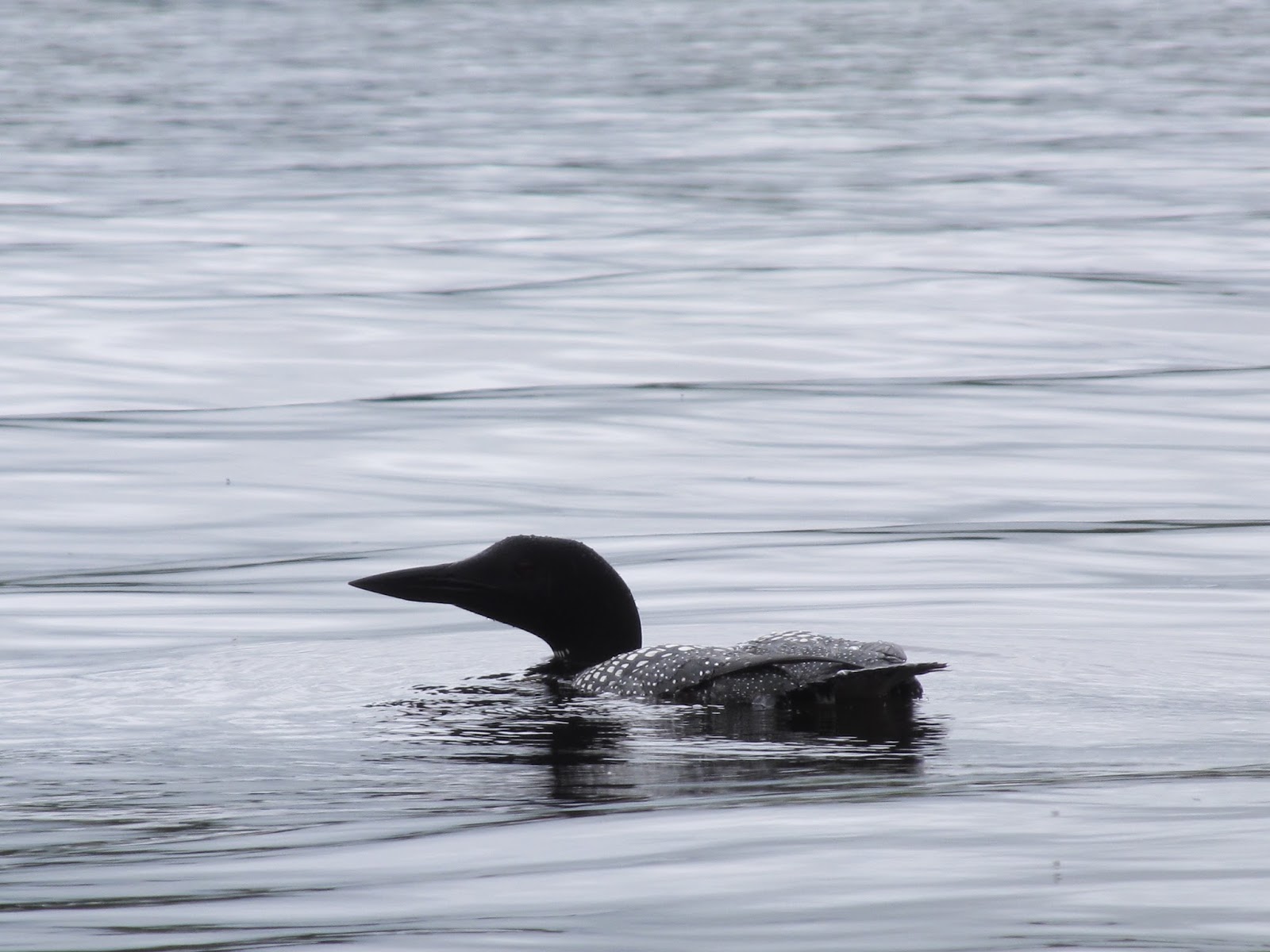
Wildlife: Ducks, Eagle, fish, frogs, and reports of moose (though I did not see any!)
Notes: I am starting with the details of the pond, but following the information about the pond I am including a point of interest that is worth seeing along the way and sharing a bit about my adventure in getting to the pond.
Once you get to the pond, you can see the perimeter of the pond from the launch area. It is a small pond. When I was there it was also a very busy pond. My favorite feature about this pond is that it is surrounded by beautiful hills/mountains. It made for a really beautiful backdrop to the pond, no matter which way I was facing. The scenery was beautiful. With a perimeter of just over two miles, it is a quick paddle. (If I were to do this trip again, I would pair it with another pond or two, to feel like I got the most bang for my buck after driving for about an hour and a half. If I lived in this area, I think it would be a place I would frequent. (I was motivated to come here after a friend suggested that this may be a spot to see moose. I miss seeing moose in northern Maine and was hoping to get my 'fix.' Spoiler alert- no moose were sighted!)

This is the view form the launch area, sets a great tone!

Directly across from the launch were these wind turbines that are part of Spruce Mountain Wind Project.


It was nice to see the hills, all the greens of the different trees. I bet this would be a beautiful fall destination.


I would say one of the unique features of this pond compared to where I have kayaked before are the ledges that go into the water like this.

There were a lot of people on the water here. There were canoes, kayaks, a paddle board, and a sailboat. There were also a lot of people in the water despite the shallow water.

The rocky shoreline was really pretty.

People here utilize their property to the fullest extent. They use the rocks as part of their yards and find ways to set up benches and even fire pits which you may be able to see in this photo.

There is an island in the pond that seems like a gigantic boulder. Kids were jumping into the water from the exposed rock. It was a very popular gathering spot for people here. I assume the depth of the water there is deeper. (I hope!) As I was passing behind the island these ducks swam towards me, really closely. I put on the brakes and let them cross!

Behind the island I found this area. I was hopeful that this was a place where I could explore more, to go into the stream here, but the vegetation was too thick.


This is the shoreline near the launch site. It is one of the few areas where there are not a lot of houses.

As I returned towards the launch site, I kept my eye on a tree where I had seen an eagle land. This eagle sat long enough for me to get a few pictures.


Looks like this eagle was keeping watch over the pond.

This is a beautiful little pond. I would love to get here early in the morning or stay on the water late into the evening as I am sure the sunsets are amazing. I had planned on staying longer to see if the moose did come into the pond as the sun was setting, but...my drive to the pond was an adventure filled with dirt roads that made me think I needed to make sure I was off the water and off the back back roads before I lost daylight. However, with the directions above, I would have a bit more confidence! (more on my driving adventure below!)

More to the story...
So... I have been wanting to do more exploring, to stretch the radius of the area where I usually paddle. As I mentioned above, I really was hoping to find a place where I could find some moose and a friend said that Concord Pond was a place he had seen moose... so I got out my Gazetteer and eventually found it. It looked like it was in a pretty remote area so I thought moose sightings were likely and decided I had nothing to lose in trying it out. As I looked at the maps (the Gazetteer and google) I saw that there was a place called Snow Falls along Rt. 26 in West Paris. From what I found as I researched it, I learned it was a rest area and decided it would be a great place to stop for lunch on my way. It was a beautiful spot! I highly recommend taking time to stop here and walk around. It is very interesting. I haven't taken time yet to research the history of this spot, but based on the rock structures along with some brick, there has to be a story here, and a good one! Here are a few pictures...

The sound of the rushing water was beautiful and there was a breeze close to the water.

If you look closely you can see that the tunnel here is made of brick and stone...

After leaving the rest area I kept going on Rt. 26. In looking at the Maine Gazetteer I decided I would, from 26, in West Paris, take Rt 219 to Tuell Hill Rd. to Redding Rd./Shagg Pond Rd. to Concord Pond Rd. On the map it looked like a solid plan. Well, my friends, looks can be deceiving. (Though, now that I did it, I will say it was a fun adventure! However, if I had gotten lost... I am pretty sure that I would have found sasquatch!)
So... When I turned from Rt. 219 onto Tuell Hill Road, I was a little surprised because it was a dirt Road. (Though I should NOT have been surprised because in some of the reading I had done online I had seen somewhere that there are times that these roads are closed... which, having driven over them, now makes perfect sense!) Not long after turning onto Tuell Hill Rd. I got this beautiful view. I had to stop and take a photo. I should have taken a panoramic photo with my phone, but I didn't. It was beautiful! (I should note... This dirt road, compared to the rest, is in AWESOME shape... and wide, very very wide!)

From there.. the road narrows...and twists...and turns... and goes up and down... and it was narrow.. did I mention that? In places the gravel on the road was loose, there were places that seemed to be washed out with deep trails where water had powered away the dirt... at one point I saw a small hill, but a very steep small hill... the way the road was I could see that there was nobody coming form the other way so I slowly climbed the hill... and at one point the only thing I could see was the hood of my truck! Not kidding! It was that steep... I was grateful it was a small hill and was relieved with I crested the hill and could see the road ahead of me. (I did think about turning back and turning around, but there were no places on the road to turn around... well very few...) After climbing that hill (in 4WD, which I am not sure I really needed, but I left my 4wd in automatic so that it would come on as needed and it did activate a few times, and I was glad I had it. Good thing I bought my new truck after all!) After that small hill I kept going... and as I descended another hill three HUGE turkey vultures were having a meeting in the middle of the road. They were unhappy that I showed up and were noisy about it. They flew towards me, over me, and I was in awe of their size. I had never seen them that closely. (I am a bit embarrassed to admit as they flew over the truck I ducked! I do that in parking garages too, anyone else do that?)
After all that drama I came upon a few camps and felt relieved. Then I saw this beautiful sight:

This beautiful small pond is Shagg Pond, though my gps labeled it Washburn Pond, but because of its proximity to the road, Shagg Pond Road, I was on, I am sure it is Shagg Pond. It was beautiful. I almost stopped to put in my kayak... there was a small area where I could have launched, a little boy and his mom were enjoying the beach. But, because I was not familiar with the area and had Concord Pond in my sights, I chose not to paddle here, but in hindsight, I wish I had. Because Concord Pond was small, and this pond is even smaller, I would have had plenty of time to do both.
So after seeing Shagg Pond I realized that the pond to which I was headed would likely also be as beautiful and I was excited. To get there. As described above, it is a beautiful pond.
When I left Concord Pond, as described in the directions above, I ended up on Milton Rd. which connected me to Rt. 232 (ahhh Pavement!) and as I came out onto Rt. 232 I was met with this beautiful field... rows and rows of potatoes. I was compelled to stop. It reminded me of my childhood. I grew up in a small town, and my family grew our own vegetables and we depended upon them throughout the winter. We grew potatoes and ate them often. (So often I rarely buy potatoes, if I eat them it is at restaurants or at other people's houses.) I have fond memories of picking potatoes with my dad...and following hi through the rows of plants picking off the potato bugs that were damaging them. I didn't think much of it at the time, I just picked the bugs off and threw the into the repurposed coffee can Dad carried with us. (There was kerosene in the coffee can, to kill the bugs.) I remember loving that time with my dad, just tagging along, doing whatever he was doing.


Driving on those roads also reminded me of my childhood. Dad loved
going on adventures like that. Our family had a 1984 GMC Jimmy with 4
wheel drive.. and we took that thing off roading! Well Dad did... Mom
hung on for dear life. Dad took that thing on old fire roads up near
Katahdin and I remember covering my eyes sometimes because I didn't
think we could possibly make it over the boulders he climbed!
Yesterday's paddle... was, for me, more about the journey than the destination. While Concord Pond, the destination of the day, was beautiful... I think I needed the rest of the day too. I needed to be driving, driving with the windows down, music cranked, singing at the top of my lungs and feeling... feeling happy!
I got home, grateful that I enjoy time by myself for days like this. I decided to end my evening with a fire in my fire pit. I haven't used it much yet this summer...and when I do, I usually invite people to join me... but not this time. I wanted to sit, feel the warmth of the fire, hear it crackling, and smell the smoke... I did just that...and watched the moon rise over the trees in my yard...

It was quite the perfect day!