My Book!!

One opportunity that the blog has brought me is the co-authoring of a guidebook, Paddling Southern Maine! It is something in which I take a lot of pride! My writing partner, Sandy Moore, and I have created a book with 54 amazing trips that are within about an hour of Portland! Our motto as we wrote the book was wanting to 'get people to spend the day on the water and not in their cars!'

If you want more information on our book please click on the image of the book below.

Sandy and I are available to attend/present various functions/events. Please email me at mainekayakgirl@gmail.com for more information!

Saturday, August 6, 2011

Bridgton, Maine: Moose Pond (Shawnee Peak/Pleasant Mountain)

Body of Water: Moose Pond, Bridgton, ME [Maine Gazetteer Map 4, A3]

Directions (from Portland, ME): Take Rt. 302 north.  Go through North Windham, Raymond, Casco, and Naples into Bridgton.  Once in Bridgton you will stay on Rt. 302 (which means turning left onto Main St.at the light.)  You will drive through the down town part of Bridgton and will continue on Rt. 302 towards Fryeburg.  After passing Highland Lake on your right, continue for three or four miles.  You will come to the causeway/bridge at the base of Shawnee Peak/Pleasant Mountain that separates the two sides of Moose Pond.

Boat Launch: The boat launch is on your left when you first come upon the causeway.  The boat launch is quite wide, big enough for good sized boats.  There is a person there who monitors the use of the pond and checks watercrafts for millfoil. 


Parking: Free.  Park along Rt. 302 on the right side (when facing the mountain.)  We had four vehicles in  our caravan and were able to have plenty of space to park. 

Wildlife: The day I went here we saw a bald eagle shortly after getting into the kayaks.  It was too far away to see well or photograph, but we saw it dive and catch a fish!  We did not see any turtles, but I suspect it was because we were there early on an overcast day and the turtles like to sun themselves. There were so many water lilies.  I have never seen so many lilies in one body of water.  (We paddled on 8/5/2011.)  We saw ducks and Canada geese.  I also caught a quick glimpse of a frog.  (I have been told that there are a lot of loons here, but we did not see any. I wonder if it was because of so many lily pads.)

Notes: Moose Pond is a big pond. Rt. 302 separates two parts of it.  You can access both sides from the water by going under the bridge.  The bigger part of Moose Pond is on the side with Shawnee Peak.  This side will be more choppy on windy days.  Bigger motor boats are allowed and use the bigger side of the pond.  We spent most of our time there on the smaller side of the pond.  (Opposite of Shawnee Peak.)  The smaller side offers many coves to explore.  There are some rocks that are slightly below the surface in some places.  While we were able to clear them a lower water level may have left us a little tippy.  There were a few islands in this part of the pond that were fun to paddle around.  Rt. 302 is busy so I do recommend unloading kayaks at the boat launch and then parking; carrying kayaks across Rt. 302 may be a challenge.  When we were ready to leave the pond, the boat launch was quite busy.  We tried to be respectful of the other water-goers by waiting our turn and staying out of the way of the vehicles with boat trailers. 

I am including some pictures of our trip to Moose Pond.  The quality of the pictures do not do the pond justice.  I need to learn more about how to use the manual settings on my camera when it is overcast. 

The kayaks are lined up and ready to go!  (My friend Holly was the first to get in hers!) 

One of my friends insisted I put a picture of myself on the blog, so here I am:

After leaving the blat landing we paddled to the right and followed the causeway to the bridge. 

Going under this bridge was a piece of cake.  (No signs of spiders either!)

There is a picnic area on an island in the middle of the causeway. (non Shawnee Peak side) I am not sure if there is parking in the rest area, but there were a few picnic tables and this particular spot had, what appeared to be, a little charcoal grill.


This is a stump that is covered in moss.

  You can see off into the distance and also some large pine trees.  The pond is quite large, and because we went in early August, you can see the lily pads. There were some rocks along the shore.   I love that part of Maine...seeing large boulders along the shoreline. 


These Canada geese were eating the tops of these plants/grass.  It was fun to hear them, their beaks, as they ate. 

The sun started to peek through the clouds, making this Peak a bit more clear. 

There were several ducks on one part of the pond.  The rest seemed to avoid us, but this one seemed preoccupied with getting her lunch!  

On the smaller side of the pond there was a place that looked like either a camp or perhaps an association meeting place.  I liked that these chairs were all lined up to look over the water.  There is something about sitting on the edge of the water... not as good as being ON the water, but nice!


 Water lilies!  

There were some tiny lily pads with tiny white flowers.  I had seen the tiny lily pads before, but never the little flowers. 

This is one of the islands in the pond.  It was more green than this, but it doesn't show in the lighting on this overscast day.


This was the Moose Pond Crew for this day! (minus me, I am behind the camera!)


 This is the bigger side (Shawnee Peak side) of Moose Pond. As you can see it is much more open and didn't have nearly as many lilies. This side is used more by boaters for tubing/water skiing. 


 A close up of a lily.  

Thursday, August 4, 2011

Cape Elizabeth, Maine: The Spurwink River... or not...

Today's original paddling plan was to go to the Spurwink River in Cape Elizabeth.  I had been looking for a place to put in and thought I had found the perfect spot. 

We parked at the interseciton of Spurwink Road and Rt. 77 in Cape Elizabeth.  (Part of The Rachel Carson Wildlife Refuge.) This is what people reference as the Rt. 77 bridge.  We thought we could put in there, there appeared to be a decent place to put in and take out.  We saw other people there kayaking. 

After we unloaded the kayaks, one of my fellow paddlers saw a sign that said. "No Access Beyond This Point."  We debated about what to do... and I found a sign with a telephone number on it, and we called it.  We asked if we could put our kayaks in there. 

We were denied. 

And we did the right thing... we re-loaded the kayaks and found an alternate spot, which as it turned out was a GREAT paddle.  We did the Nonesuch River instead.  (See last post.) 

I am determined to find a spot where I can put my kayak in so I can paddle the Spurwink... I may have to give in and just put in at Higgins Beach.. but we'll see!

Stay tuned!

Wednesday, August 3, 2011

Scarborough Maine: Nonesuch River Kayaking

Body of Water: Nonesuch River, Scarborough, Maine [Maine Gazetteer Map 3, B3]

Directions(from Portland, ME): Take Rt. 1 South into Scarborough, At the Oak Hill Area (Intersection of Rt. 1 and 114) you will turn left onto Black Strap Road.  You will drive on Black Point Road (Rt. 207)  for about a mile and a half and you will turn right onto Clay Pit Road.  Go to the end of Clay Pit Road to the public boat launch. 


Boat Launch: The boat launch is great!  It is a public boat launch with plenty of room to put in and take out. 

Parking: Free.  Plenty of parking spaces, set up well.  There are no public bathrooms at the boat landing. 

Wildlife: Several bird and plant species.

Notes: Paddling the Nonesuch River is a wonderful way to spend a few hours!  The river has sharp corners which are fun to navigate.  The current, at it's peak, is pretty strong.  You will go along at a pretty good clip as you paddle along the river.  You will paddle under a railroad trestle and will also paddle under Rt. 207 (Black Point Road.)  After going under Black Point Road there are some downed trees in the water, so just paddle carefully.  This is a great paddle for people who have spent enough time kayaking to build up enough endurance to do a 4 hour paddle.  After paddling for a long time, we came to a place where you could turn right or stay kind of straight... turning right meant we continued on the river.  Going straight looked like we would have hit some rougher water, but we later learned it would have taken us into a pond.  As you paddle you will pass some houses and as you approach Black Strap road the sounds of the traffic are kind of loud, but the rest of the paddle feels like you are far from civilization.  There are a few duck blinds along the river which means I would not paddle back there in the fall.  (But duck hunters may love it!) 
I think I prefer this paddle over doing the Scarborough Marsh.  The way the river turns and the variety of plant life as the water changes from very salty to being more freshwater.  I also like that the river is wide enough to have your paddling partners next to you for easy conversation. 

*Tide: Pay attention to the high and low tide times.  If you plan to paddle up the river (away from the ocean) and want to paddle for about 4 hours , I would advise putting in at the boat landing about 30-45 minutes before the high tide is listed for the beach  and allow the current/tide to push you upstream.  Because you will be further inland, the time of high tide is delayed.  We paddled today and learned from some folks sitting on their dock  that the high tide at their house is about an hour and a half later than high tide hits the beach.  So, if you paddle for a couple of hours upstream, you will be able to turn around as the tide changes and ride the tide back to the boat launch.

* Update 9/5/2014: A loyal blog reader paddled the Nonesuch River recently and offered some advice worth sharing here. Getting in and out of one's kayak here is difficult, very difficult.  Because it is tidal, the banks are steep and muddy, making it difficult to get your footing.  The blog reader who shared her story said she was paddling when nature called.  While she is an experienced paddler, she did not anticipate the slippery mud and depth of the river in the place she tried to get out.  Unfortunately she fell into the river, with her camera around her neck, and had to swim for a while, paddle in one hand, kayak in the other.  Fortunately, this blog buddy is, like me, a 'kayaker for life,' and this experience did not deter her from future paddles.  This is a good reminder that in places where tides change and/or water depths change quickly, paddling with someone is a good idea.  In this case the paddler still may have fallen in the water, camera and all, but... may have had some moral support and may have been able to get back in her kayak more easily.  Also, a good reminder to use the nearest bathroom before getting on the water, and if you have to get out of the boat to become one with nature, be as careful with your choice of location as you can!  I am grateful that people who read the blog share their experiences! 


This is the start of the adventure!  

This is one of the duck blinds we saw... at first we wondered if we had come upon an outhouse!

This is the railroad trestle.  You will hear what sounds like rushing water as you approach.  There is no waterfall, just the current against the bridge!


We made it under the trestle just before the train came through.  (This is actually the back of the train, I didn't get my camera fast enough to get the front of the train on the bridge!)

This is what the river looks like most of the way. 

This is the Rt. 207 bridge (Black Point Road)


Along the river there was  a lot of foam on the water.

I am disappointed in the quality of this picture, but it is the best one I got today of this bird.  I am on a quest to get a better picture of a white heron/egret.  (I think that is the name!)

It is beautiful out there!

It was nice to be on a river, and it was cool that it was tidal!


Another beautiful spot!

I liked this grass.  There were different kinds of grass along the river. 


This was a large bird, I think it is a hawk, but it was a little too far away for my camera. 

I love this picture!  Had to share it!

The clouds were so fluffy today! 

It was neat to see the sights as the tide levels changed. 
On the way in I was a lot lower as I looked at this log. 

As we paddled back, and the tide was going out, you could see and hear the water draining from the marsh. 


This could become one of my favorite spots!

Tuesday, August 2, 2011

Casco/Raymond Maine: Thomas Pond

Body of Water:  Thomas Pond, Casco/Raymond, Maine [Maine Gazetteer Map 5 B/C, 1.5]

Directions (From Portland, ME): Take Rt. 302 North, through North Windham and through Raymond.  After going through Raymond Village you will come to the intersection of 302 & 121, stay straight.  Sebago Lake (Raymond Beach) will be on your left.  At the next point on 302, where you are crossing water, is Thomas Pond.  (Maybe about 3 miles beyond Raymond Beach.) Launch site is on the left of 302 when heading west/north. 

Boat Launch: To launch here, there is a wide shoulder along Rt. 302.   People put in on the southwest side of the bridge. You can paddle around in the area where you launch, but will hit a dead end.  Then to access Thomas Pond go under the bridge and just keep going.  The beginning part of this paddle, from Rt. 302, will feel like you are on a small pond, but it opens up to a very large pond. 
There is also a very small hotel on the right side of Rt. 302, across from the boat launch.  They may allow people to launch from there, but I am not sure. 
*I usually launch from the camp of one of my friends.  I have not launched from the side of Rt. 302, but have seen people launching from there. 
This is the boat launch, on the left of Rt. 302 (Heading away from Portland):
 This is the spot where you put in, just beyond that last vehicle parked on the left. It is dirt, and narrow, but plenty wide for kayaks! (To access Thomas Pond, you will paddle to the right and go under Rt. 302.)


Parking: Free.  There is a small place that looks a bit like a driveway where people launch from to leave vehicles. Limites spaces, but again, the small hotel just ahead, may allow people to park there. 

Wildlife: Turtles, Loons,  Ducks, and canada geese. (My friend's sister claims she saw a moose early in the morning!)

Notes: Pay attention to where you come onto the big part of the pond, so you know where to return to get back to your vehicle. There are a few places that look similar. I find paddling along the shore in the same direction will eventually get me back to where I started from. Thomas Pond is a good size pond to paddle around the whole thing, very enjoyable!

This was my first glimpse of baby loons! I was so excited! 

Both parents catered to both babies, although I noticed that they offered fish to the same baby and when that baby refused it, the other baby would get fed. 
I am not srue if this is typical or not, but fun to watch. 

A sunset at Thomas Pond.  

A water lily. 
 Turtle! This is a painted turtle.  I have also seen a good sized snapping turtle swimming in the water.  (I named him Terrance the Thomas Pond Turtle.)

This is a shot of some of my friends on one of our kayaking adventures.  It isn't a great picture as far as the exposure goes, but shows that the pond has many houses/camps on it.  

Kayaking North of Millinocket: West Branch of Penobscot River. T2R10/T3R10

Body of Water: West Branch of the Penobscot River [Maine Gazetteer Map 50, D/E 5].  There are a few places along the river to put in.  I put in at Abol Bridge Campground because I camp there when I am up that way.  The campground is under new ownership and the new owners may allow people to launch from the campground, but you would need to check in at the campground store to check. 

Directions (from Portland, ME): Head North on 95 or 295 (which merges with 95 just south of Augusta.)  It will take you about 4 hours to get there from Portland, so definitely worth taking a weekend to enjoy the northern Maine woods!  From I 95, you are going to exit at Medway, exit 244.  (Exits on 95 are now numbered by mile markers.) Coming off the exit you will want to turn left onto Rt. 157.  You will stay on Rt 157 through Medway and East Millinocket into Millinocket. 
Once in Millinocket you will go past a couple of grocery stores (if you need any supplies, get them here!)  You will go down a hill and over a small bridge, seeing a traffic light ahead.  You will want to go straight through the traffic light.  This will take you around a corner with an old school on your right.  stay on that road as it turns to the right.  You will see a green sign that says Baxter State Park with an arrow telling you to turn left.  Turn Left towards Baxter State Park.  This puts you on the State Road.  (Not sure if that is the real name of the road, but it is what the locals call it!) 
Once on the state road, you will go under a railroad trestle (The Aroostook RR) and soon you will lose cell phone reception.  (Don't be scared, enjoy the freedom of being signal-less!) 
The State Rd. will take you past a campground/white water rafting company and into Millinocket Lake.  Once you enter Millinocket Lake, you will see the North Woods Trading post on your right.  At that point you will notice that there are two roads, running parallel to one another, the State Rd. and The Golden Road.  I suggest Switching over to the Golden Road.  (Be aware that the Golden Road is an active logging road that has no line markers.  There will be logging trucks with LARGE loads of wood barrelling down the Golden Road.  You will want to stay to the right as far as possible when these guys pass you.  This also means that stopping along the side of the road can be dangerous.  If you stop, make sure your vehicle is completely off the road.Also be aware that this is moose country.  Keep your eyes wide open for moose and deer.  Moose sightings are most common in the evenings, but can be anytime.) 
Once on the Golden Road you don't have to worry about any more turns.  Just stay on that road.  You will pass Compass Pond on your right and River Pond on your left. (Good Moose spotting sights!)   As you get close to Abol Bridge Campground you will round a corner and see Mount Katahdin in all its glory (unless it is cloudy).
Abol Bridge Campground is on the right before the bridge.  Stop at the store to check in, if you are camping, or to see if you can launch your kayak from there.  I do recommend camping there, it is a nice place to be. 

Boat Launch: There is a beach area at the campground where putting your kayak into the river is easy.  There are also several campsites along the water from which you could launch your boat.  (If you get one of those sites.) 

Parking: If you are camping there, you have no parking issues. If you are just using this spot to launch your kayak, You will want to park your vehicle back up by the store. 

Wildlife: Moose, deer, loons, ducks (mergansers and mallards), beavers, eagles, osprey, turtles (snapping), maybe a fox or a bear.  (And white water rafters.. who can be very wild!)

Notes:  This is a place that is sacred to me.  This is where I learned to canoe and kayak and where I have spent much time with my family and with close family friends.  This is a great place for families, a great place for beginner paddlers or more advanced.  From the beach (or if you stand on the bridge looking at the mountain/river) if you look to the right you can see a very calm place to kayak.  This is Abol stream.  It is a great place for kids to learn to paddle and also a great place to see some wildlife.  I have never gone under the bridge in my kayak, again, I am not a whitewater fan.  I like paddling up the river and then letting the current bring me back to the campground.  The current in this river is stronger than other places I normally paddle, but easy to navigate and well worth the effort.  As you paddle up the river there are smaller pond like areas/streams that are fun to explore.  My mother and I named each of them, including Tadpole Terrace (which is off to the left and now blocked off by a beaver dam.  To get into Tadpole Terrace you would need to portage over the dam) and Baxter Bay, where there is an amazing view of Mt. Katahdin

I must once again remind people to respect the wildlife.  Do not get too close to the animals.  Some of the moose up here are used to seeing people using the river, but need to be respected.  Moose can move quickly on land and in water.  Mothers are very protective of their babies, born in early spring.  Males are more aggressive in the fall, but can be unpredictable year round!

Water levels on the river can vary.  Higher water levels mean stronger current.  You can paddle quite a while up the river before the current gets strong.  Some people put their kayaks/canoes in just below Nesowadnehunk falls and float down to the campground.  If you choose that option, be aware that the current moves pretty fast from the bottom of the falls until leveling out into some flatter water. 

 This is a picture of Mt. Katahdin taken from "Baxter Bay," one of the many inlets along the river.


  This is taken from another part of the river, on a cloudier day.  

 This is the beaver dam blocking the entrance to "Tadpole Terrace!"

This is a picture looking up the river from one of the campsites. 

This is looking up the river.  (That's Alan, a family friend in his boat!)
Many people fish the river, catching trout and salmon, if you are lucky!

It is hard to see in this picture, but those two kayakers are a couple of my good friends.  Look closely on the left and see a moose.  Moose are a common sight along the river, especially in June!

This is a picture taken from the campground looking over Abol Stream, which connects to the river. Water levels here vary greatly, but you can always find a paddling route!

This is taken as I paddled behind the island that is in the river. 

 This is an immature bald eagle.  I took this in 2010.  There were two immature eagles around the river that summer.

 A family of merganser ducks.

 One of the amazing sunsets... taken from the beach area of Abol Bridge Campground.  

A Maine loon.  If you are up here and hear a loon, look up, chances are you will see a bald eagle in the area.  The loons warn each other about the eagles. 

 This was taken on a very calm evening.  It is hard to tell if this is right side up or not because the  reflection is so clear.

 Another beautiful sunset.

 And another...

 This young bull was enjoying eating some grass that grows on the bottom of the river.

This is a shot of one of the eagles I got to follow up and down the river.  Last summer I got to see one dive into the water, catch a fish and sit on a log and eat it.  Unfortunately I was too far away to get a great shot. 

This is part of Mt. Katahdin, some ledges.  Can you see that it looks like a skull?

Another Loon sharing its day with me.  
 

Another young bull moose.  Male moose grow antlers which fall off every fall.  It is fun to watch the moose during the summer as their antlers grow.  You can see that the antlers look fuzzy, that's because when antlers are growing they are 'in velvet.' The velvet is a skin that covers and grows with the antlers. As the antlers mature, the moose will rub against trees to remove the velvet, leaving the more white, bone looking, antlers people are used to seeing in pictures.  

 This eagle keeps a close eye on the river, looking for food. 

Another bull moose.  This picture was taken on the same day as the one above.  This is an older more mature moose.  This is the same moose seen in the misty pictures below. 

 This is not a picture of a log.  It is a picture of a whippoorwill sitting on its nest. 
If you look closely the bird is facing the camera.  (Not taken while kayaking, but taken in that area.)
 This is a baby whippoorwill.  I cannot say it is a cute baby, but it is something I had not seen until this summer.  I did not find the nest, some family friends came upon it while collecting firewood. 

This beaver stayed above water for a long time as I was paddling.  It was chewing on something; as soon as it was done snacking it submerged itself and swam away.

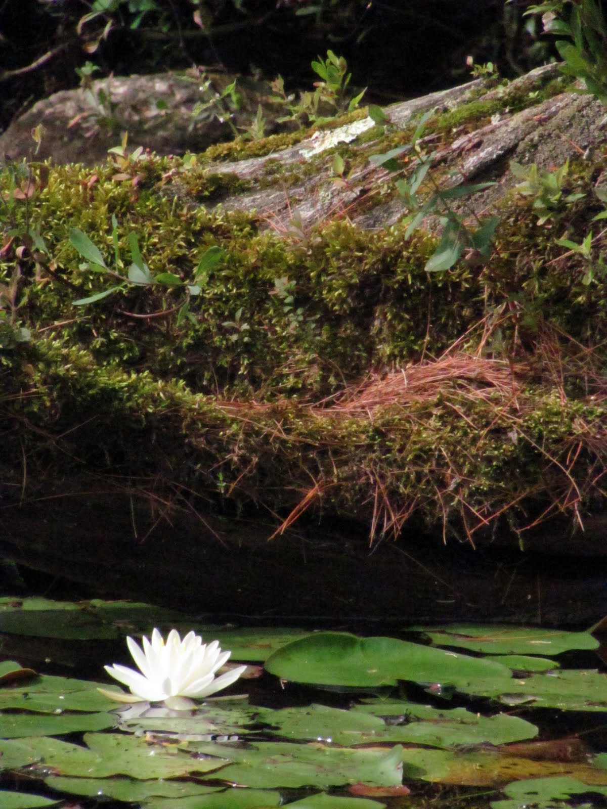
 Along with critters, there are a lot of wildflowers, like this iris, along the river. 

Moose in the mist.  One evening as it was starting to rain and the mist began collecting on the river, my dad spotted this bull feeding along the river.  (We could see it from the campground.)  Despite the rain, I needed to go out on the water and capture this in pictures.  It was an amazing experience to see such an amazing animal in the mist.)

 I was able to anchor my kayak behind a tree that hung over the river and offered me a great place from which I could photograph this moose.  I was probably 20-25 feet from him.  He kept looking at me, making sure he knew where I was and kept eating. To be close enough to hear this animal chew its food is a gift. 

The quality of this picture is not great, but it captures a rare moment,
a moose and a deer within feet of each other. 
 

This is part of the Appalachian Trail(AT).  To get to it I simply walked out of the back of the campground.  It is a beautiful place.

 This is a group of ferns along my path.

 This is another part of the AT.

 This is the bridge that crosses Katahdin Stream, again part of the AT.

Getting to this part of Maine may take some time, but is well worth it.  Many people who climb Mt. Katahdin stay at Abol Bridge Campground.  To me, THIS is truly Maine.