
This was an event organized by the Presumpscot Regional Land Trust. I had never paddled this part of the Presumpscot. I did not know it was accessible. I will definitely be back!!
Body of Water: Presumpscot River, Gorham, Maine. [Maine Gazetteer Map 5, Between E2 and E3]
Directions (From Portland, ME): From Portland take Brighton Avenue (Rt 25 towards) Westbrook. Stay on 25 through Westbrook. From the intersection of 25/Maine St. and New Gorham Rd. Stay on Rt. 25 for about 1.8 miles. At the light bear right onto Rt 237. Drive on Rt. 237 for 2.9 miles entering a small traffic circle. Take the first right onto Rt. 202 (Gray Rd.) Drive 0.3 miles and turn left onto Tow Path Road. (There is a sign at the end of the road indicating Winham Gorham Rod & Gun Club.)

Drive about .3 miles to the end of the road and you will find a small parking area on the left along with a kiosk with some information about the area.


Drive about .3 miles to the end of the road and you will find a small parking area on the left along with a kiosk with some information about the area.

Boat Launch: From the parking area there is a very short walk to the boat launch. The boat launch is a bit steep. There is a set of stairs and a boat slide that is very helpful. There is a gradual put in into the water.
Looking down to the river from the top of the stairs.

Looking back up at the stairs and launch ramp from the water.

Parking: Free. There is a small area for vehicles to park. Parked tightly you could fit 4 vehicles there plus there is a dedicated handicap parking spot. (I didn't think to get a photo of the parking, but will add a link to the Presumpscot Regional Land Trust website if they post any pics!)
Wildlife: Turtles, dragonflies, blue herons, ducks, and I would suspect deer visit this part of the river as well!
Notes: Despite the forecast calling for rain just over 20 people joined the Presumpscot Regional Land Trust on their first ever paddling event! I am not certain of the age range, but there were a couple of young kids (maybe 4 years old) and there were participants who could have been grandparents to those kids! (A creative way to avoid trying to estimate the age of people on the trip!)
We all gathered in the river at the bottom of the launch ramp to hear a bit more about the Presumpscot Regional Land Trust (PRLT) and the waters of the Presumpscot.
*Disclaimer: I recommend people wear their life jackets all the time. I would strongly recommend they are worn on this trip. The current picks up as you approach the dams, there are several downed trees, and unexpected shallow areas that, if caught at the wrong moment combined with the current could result in tipping over. The photos include people who are not wearing life jackets. I respect that it is an individual decision, but I was glad to be wearing mine today! This is a spot where water conditions could change quickly dependent upon water levels. (Okay, public service announcement over!)
As loyal blog followers know I love the Presumpscot River. It is one of the places I paddle most often. I love watching the seasons change from the perspective of being on the water. In researching places for the book I thought I had paddled all of the easily accessible legs of the Presumpscot, but I was wrong! (Sometimes I love being proved wrong!) Sandy and I were invited to join this event to share our book and when I got the information about where we were paddling I was a little confused because I didn't realize this stretch of the water was accessible... my confusion quickly turned to excitement when I realized it is accessible! It is more narrow than other parts (Westbrook and Shaw Park) and feels very protected. Today one of my favorite sights was seeing the green grass under the water, it was beautiful... unfortunately I did not get a great photo of that!
I often paddle solo... and while I do believe it is safe to do so I think this is a place where I would prefer to paddle with someone else. There are a few houses along the river close to the launch site, but then there are no other houses along the way. With more water hazards than some other places I have paddled (downed trees, etc.) combined with some stronger currents than in other places to which I am accustomed, just makes me feel like this would be a good place to go with someone else... just in case!
Here are some photos from today!

Maggie was here to talk to us a bit about the quality of water.

This is Don, he is the steward for this part of the river/trails for the PRLT. Thanks Don!

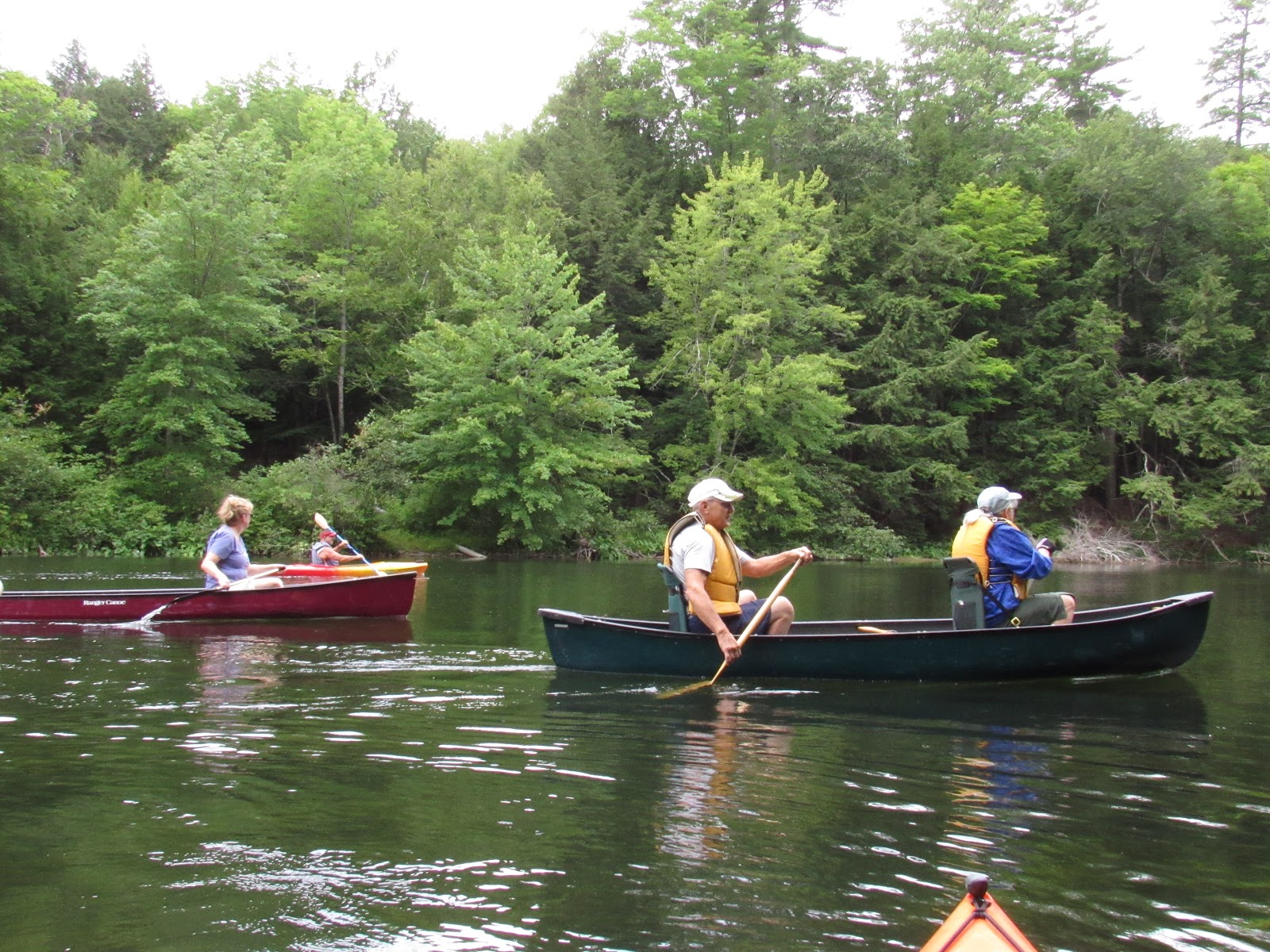
I was surprised to see so many canoes today!

Toby was the leader/organizer of this adventure. Thanks Toby!


There are trees to paddle under!

This stretch of the river stays pretty narrow. We had some decent wind towards the end and it was very protected.

Of course many of us HAD to go under the tree instead of going around it!


One of my favorite parts of today's trip was talking to the couple in the green canoe. Their daughter is one of my former students... one of my favorites!! (She was so sweet, polite, hard working and determined!) So fun to hear about how she is doing.


This heron flew off before I got any great photos. My camera didn't focus as well as it could have, but was happy to at least get a shot...

The water starts moving faster as you get closer to the dam, you can hear the dam well before you can see it.
This is the end of this branch, the Gambo Dam. The water here was shallow in some places. Shallow water can get you a bit stuck, combined with faster moving water could result in tipping so be careful! I found that staying to the left side had some deeper/easier places to pass.

This is a cardinal flower. We saw several of them. I was told they are fairly rare. They definitely stand out with the vibrant red flower.


These were the only pink lilies I saw on this stretch!

Not far from the launch there is a small offshoot that leads to this tunnel. I hear you can paddle through it... but as you can see there wasn't a light at the end of this tunnel. I think it curves a bit but I wasn't sure. I didn't have my headlamp with me so I did not venture through.. plus I was a little worried about what may be living in there!! Maybe next time!

And there WILL be a next time!
This was a great place to paddle. I am excited to return when I take the trip a little more slowly and can take more time to really appreciate the beauty here.
A GREAT trip.. the current is a little stronger than other branches of the Presumpscot that I have blogged about. Someone told me that the water was lower than usual. The current may be stronger when water levels are higher. As always, be aware on rivers, especially with dams, water levels change rapidly.
Thanks to the PRLT for inviting me to this event. It was great to meet so many great people who also enjoy paddling and appreciate the river!
Happy Paddling!
The tunnel does have curve to it and is about eighty to ninety feet long. Ralph Hatt
ReplyDeleteThanks Ralph!! I appreciate it! Is it unnerving?
DeleteRecently found your blog and purchased your book. I'm a canoeist from Maryland and have family in southern Maine, which I will be visiting next week. If you could recommend just one day trip anywhere from the NH and Portland (could be flat water or whitewater so long as no more than Class I-II) what would it be?
ReplyDeleteOh gosh... one trip... hmmmm... how much time would you like to spend on the water for the trip?
ReplyDeleteThe canoeing has been postponed, but since I will be back to Maine, a lot, it is still worth pursuing an answer! So, how about best full day trip, best half day trip?
DeleteOk.... A great full day trip... is starting at Sebago Lake State Park, paddling up the Songo River going through the Songo Lock (during the season when it's open!) paddle across Brandy Pond... and if you can find a place that will let you pull your kayak/canoe up for a bit... park your kayak at the causeway in Naples and head to Bray's Brewpub for lunch.... get back in your boat and head back to Sebago State Park and paddle out to the lake, to the sandbar, and spend the rest of the afternoon swimming in Sebago Lake!
ReplyDeleteHalf day trip... these trips are tide dependent... but you could ride the outgoing tide down the Spurwink River, spend time at the beach then ride the tide back up to the launch site... or the Nonesuch River is a great trip if you want to follow a meandering river away from the ocean and see the change in plant-life from more ocean to freshwater...Or if you want to go a bit north of Portland the Harraseeket River is beautiful. Again they are all tide dependent... for a half day non tidal trip...the Presumpscot River in Westbrook is beautiful. You can paddle a long way up the river (From Lincoln St. in Westbrook to Mallison Falls in Gorham) and then float back down. Depending on your paddling speed that could be a longer trip than a half day, but very nice! Hope that helps! Reach out anytime!
These sound great, thanks so much!
ReplyDelete